Cities and Urban Life in the Hittite World – a Trail Search
Hittite civilisation doubtless was urban civilisation. In the Late Bronze Age world of the Hittites, cities formed a ground pillar of society. Since settlements in general can be seen as a reflection of the respective social and political structures of a community, the question emerges concerning what exactly constitutes a Hittite city or how Hittite cities differ from other urban settlements.
- Yazar : Dirk Paul Mielke
- Tarih : 2021-01-17 12:28:41
The historical and natural setting of Hittite cities
The ‘urban revolution’ (V. G.Childe) took place long before the Hittites entered the stage of history. Moreover, the development of complex societies started in Anatolia a long time before. However, during the Late Bronze Age––traditionally dated between ca. 1650 and 1180 BCE––the Hittites established an idiosyncratic state formation that developed into one of the great dominant powers of the Ancient Near East in the second millennium BCE. It is obvious that the fundamental changes connected with the first great state formation in Anatolia also affected previous urban life.
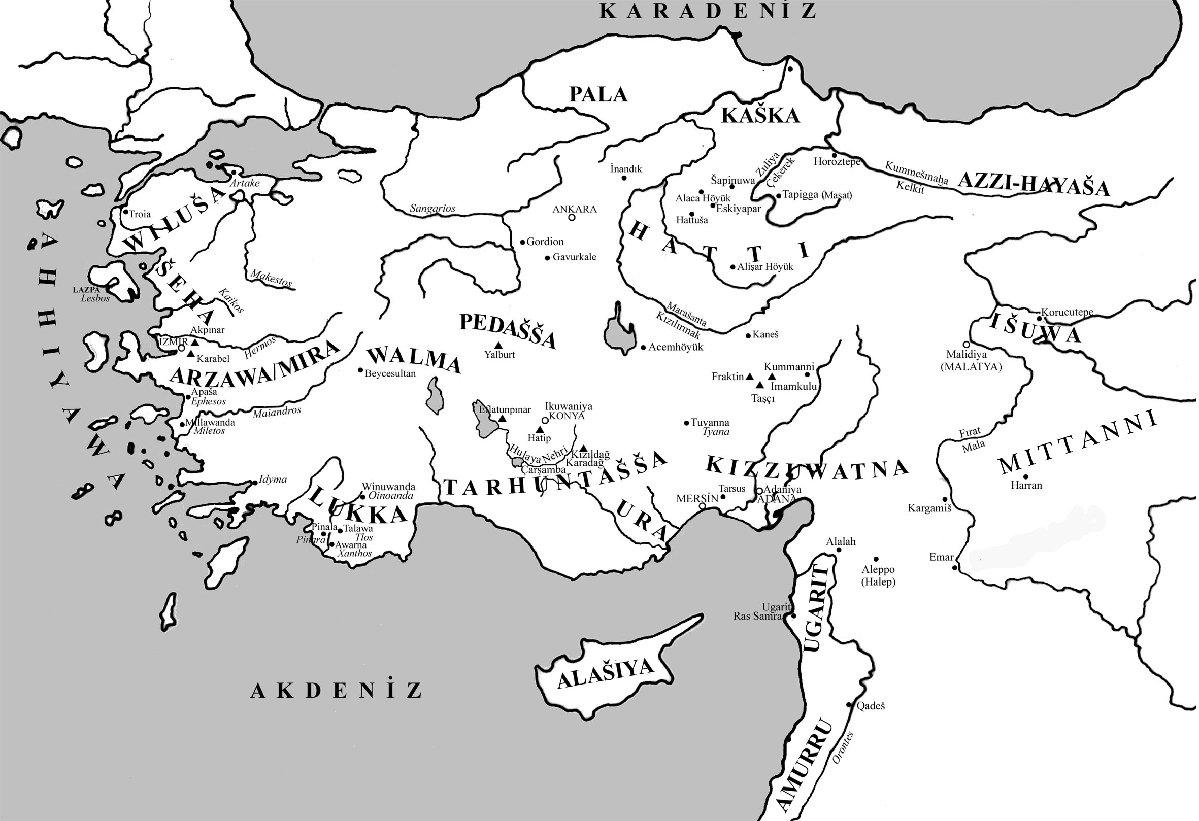
The roots of Hittite urbanisation lie in the geography and history of the landscape. The core region of the Hittite homeland can be located in Central Anatolia and the Central Black Sea region, approximately outlined by the course of the Kızılırmak, which the Hittites called Maraššantiya. The diverse landscape and the long-lasting history of the ‘Land of Ḫatti’ strongly contributed to the formation of the Hittite civilisation. Therefore, the process of development of the Hittite civilisation can be characterised by the headline ‘from Anatolian to Hittite’. This important fact is apparently demonstrated by the self-designation of the Hittites as ‘people of the Land of Ḫatti’ (the term ‘Hittite’ is of modern origin). Especially the historical developments in the Bronze Age with the rise of complex societies and urban settlements form an elementary foundation of Hittite cities. Although the political history of the Hittites is characterised by several ups and downs, the material manifestations of architecture are more shaped by the general social and political structures in the Hittite world.
Foundations of knowledge on Hittite cities
Archaeological and written information is at our disposal for our knowledge, whereby both categories of sources represent different spheres of one phenomenon. Therefore, we often face major difficulties when trying to bring the information from both sources together, which already becomes clear with the first important basic information.

In the written legacy of the Hittites, around 2,000 place names can be found. They can be easily identified since they are all marked with the determinative ‘URU’, which is generally translated as ‘city’. However, the Hittite writers attached this label to all kinds of settlements regardless of their size and importance. Only with additional information is an assessment of the original significance of a settlement possible. Nonetheless, the principal question is which of these settlements can be classified as a city. A Hittite definition is not handed down and we have to ask whether such existed at all. However, modern research regards the presence of religious or spiritual institutions, systems of power and rule, and a non-agrarian economy as the ‘three pillars of urban life’. It is difficult to apply these criteria of what constituted a city to the written record as the text sources of the Hittites are extremely focussed on religious contents and provide little information on economics, politics, and other socially-relevant aspects.
If the archaeology now comes into play, a similar picture is visible. A large number of many hundreds of sites in the Land of Ḫattiexhibit settlement traces from the Late Bronze Age and many are still undiscovered. Most of the archaeological sites are only known from archaeological surveys. This means that in most cases we only can state with certainty that a site was occupied in the Late Bronze Age, while all other statements about the character of the settlement are uncertain or speculative. Only a few sites have been investigated and analysed with advanced survey methods that enable making more detailed statements about their specific character.
By contrast, the number of sites investigated by excavation is comparatively low. Small sondages and rescue excavations dominate the picture here. However, only when a site is intensively investigated by large-scale archaeological excavations and modern survey methods can the specific urban structures and elements of a city be recorded. The main target of any Late Bronze Age excavation in Anatolia is to ascertain the erstwhile name of the city and thus establish a link with the written sources. This is only possible if clay tablets or other written documents were found during the excavations. It is easy to imagine that only a handful of sites fulfil these requirements and are at our disposal to investigate the city and urban life in the Hittite world.
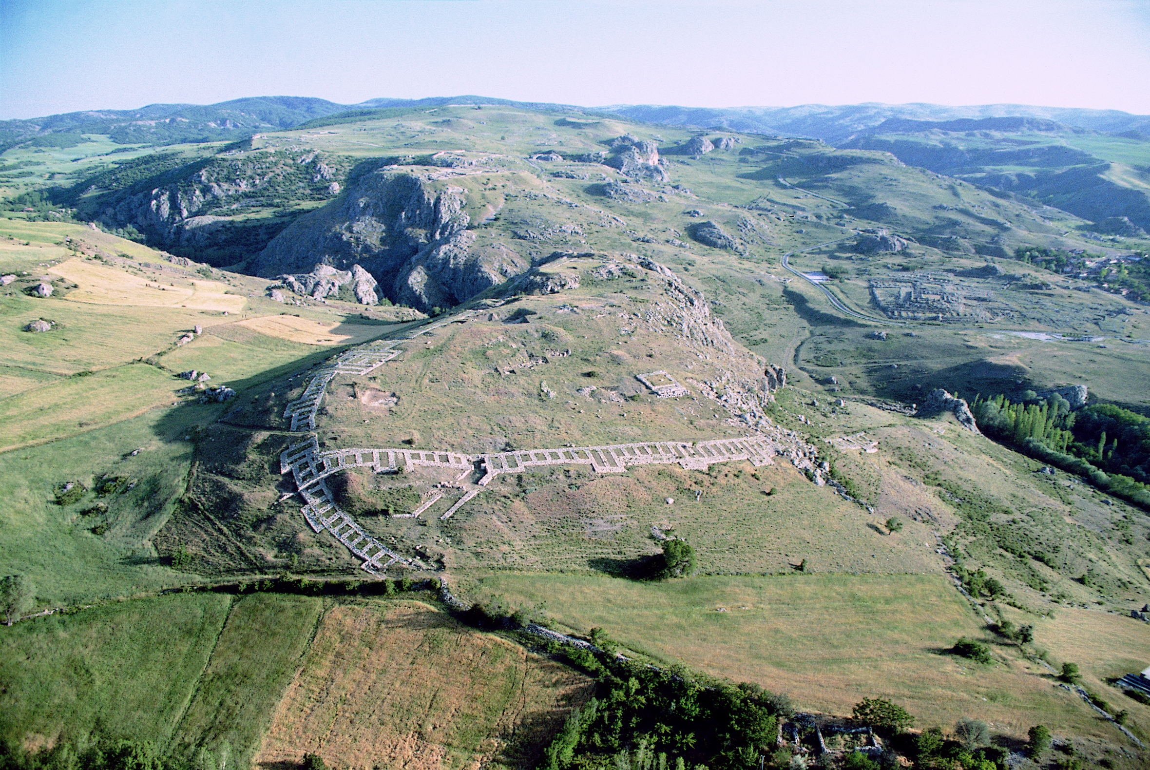
First and foremost, the impressive ruins of Ḫattuša––the capital city of the Hittites near modern Boğazkale in the Çorum province––must be mentioned. Excavation and research at this site have been taking place for more than one hundred years and it provides the ultimate paradigm of a Hittite city. The circa 180 ha huge urban area was enclosed by a complex city fortification system and its topography is sharply divided by mountain ridges, rocky crags, plateaus, and basins. Without any doubt, the site of Boğazköy-Ḫattuša was one of the most important cities of the entire Ancient Near East and today it belongs among the most significant archaeological sites anywhere, as a World Heritage Monument. However, observations made for this city cannot be readily transferred to other sites, because Ḫattušarepresents an exceptional and special case of a Hittite city.
Next to the capital Ḫattuša,there are a few other archaeological intensively-investigated sites, of which the Hittite names are more or less certainly known, including Šapinuwa, located near modern Ortaköy in the province of Çorum. The settlement presumably served as a royal residence and garrison. Another example is Šarišša, in the province of Sivas. The site with the modern field name Kuşaklı was a province centre and the only clear example of a newly-founded city. Šamuḫais also located in the Sivas province, directly on the Kızılırmak river near the village of Kayalıpınar. In Hittite times, the city hosted an administrative centre and was an important cult city. Tapikka, located at the Maşat Höyük in the Tokat province, was a border city where a governor resided. Nerikis situated at the Höyük of Oymaağaç near the homonymous village in the province of Samsun. The small settlement served as a coronation city of the Hittite kings and it was an important cult centre at the northern periphery of the Hittite empire. For several additional archaeological sites that were also more intensively investigated––such as Alişar or Alaca Höyük––a probable association with a historically-recorded name is discussed. Finally, new research projects like Büklükale in the province of Kırıkkale or Uşaklı Höyük in the province of Yozgat will certainly expand our understanding of Hittite urban life. Thanks to large-scale geophysical prospection, urban structures can be assessed on a larger scale in these cases.
Hittite urban structures by evidence
The archaeological evidence of the sites in question can be best grasped through the different structures or urban elements that can be found in the aforementioned Hittite settlements. They were generally classified according to their primary function.
Fortifications were one of the most important elements because their contour shapes the physical profile of the settlement. It is a universal phenomenon that city walls and gates hold major symbolic significance, aside from their military function. In addition to demonstrating power and rule, they were also part of ideological concepts of space and boundaries. This is apparent in the so-called tower vases, huge pottery vessels that were provided with stylised three-dimensional representations of fortifications, usually attached at the rim of the vessel. The symbolic meaning of fortifications is also apparent from the text sources. Like most Hittites buildings, the fortifications were erected with foundations of stone, whereas the rising walls comprised a specific Hittites timber-mudbrick construction. Higher stone walls are an exception in Hittite architecture. The walls were provided with rectangular towers projecting at regular intervals and several huge gates at selected locations. A typical Hittite gate comprises two massive towers with a chambered gate passage set back between them. The course of the fortifications was generally skilfully adapted to local topography. However, in places where conditions were unfavourable, massive ramparts were constructed, and the walls with their towers were built on top of them. A special feature of Hittite fortification were posterns, although they only occur in a few sites and their function remains a mystery. These are passages built from large stones using the false-vault technique that led beneath the walls through the raised ramparts.
Next to fortifications, palaces and temples most prominently define our picture of Hittite cities. The paradigm of a Hittite palace is given by the so-called royal citadel in the capital of Ḫattuša. The circa 32,000 m² huge complex is situated on the rocky crag of Büyükkale and it was equipped with its own fortification. The central feature of this building complex was an array of courtyards connected by gateways. Around a courtyard, a number of different rooms and buildings with colonnades were grouped. This complex arrangement of building structures obviously mirrors the multiple function of thepalace as a centre of power and administration. In the cuneiform texts, palaces were designated as ‘É.GAL’, which literally means ‘great house’. Generally, the linkage between archaeologically-documented and textually-recorded buildings is one of the most important and difficult challenges in Hittite urban studies, because it is often unclear whether the Hittite terms refer to a building, a group of rooms, or an institution. A palace complex surrounded by its own fortification probably also existed in the city of Šapinuwa, as the excavations suggest. Further palace-like building structures with smaller dimensions were excavated in Alaca Höyük, Maşat Höyük, and Kayalıpınar, the Hittite city of Šamuḫa. An important observation in this respect is that the country residences of a Hittite nobleman from Inandiktepe obviously had the same architectural layout concept.
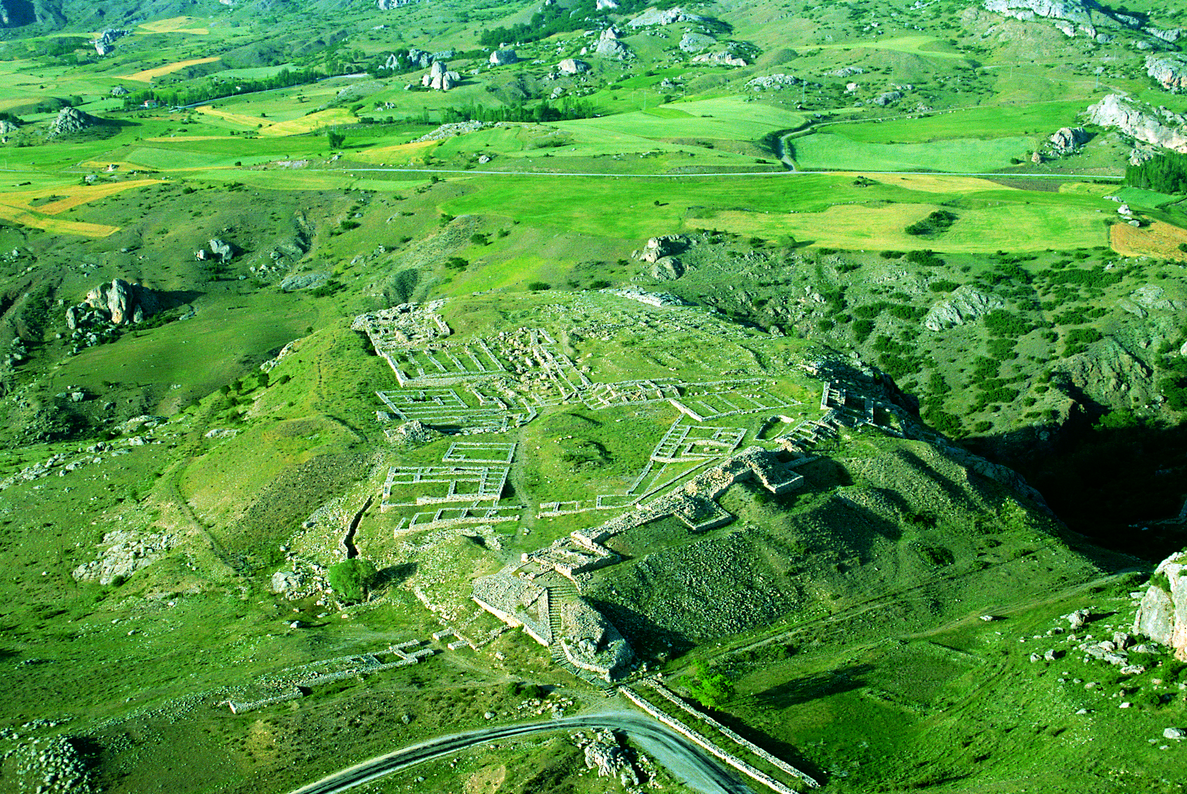
Alongside palaces, temples were another essential pillar of the Hittite city as representatives of religious institutions. However, from an archaeological perspective, it is sometimes difficult to differentiate between palaces and temples with certainty because as ‘palaces of the Gods’ temples bear a functional and thus structural resemblance to palaces. Nonetheless, the characteristic features of palaces––functional building units grouped around a courtyard––are reproduced in temples in a more dense and canonised form. Although several important temple buildings could be excavated in the cities ofŠariššaandNerik, it is once again the capital Ḫattušathat dominated the picture. To date, 30 temples have been unearthed here.
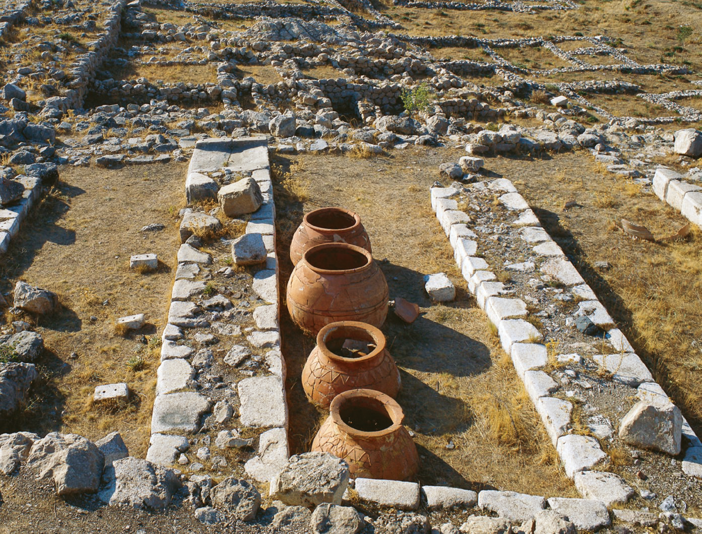
As ‘pillars of urban life’, palaces and temples were generally erected at topographically favourable locations, and in many cases this involved a massive reshaping of the landscape through constructing artificial plateaus. Especially from the texts sources, it is apparent that palaces and temples were not only centres of dominion, power and religion, but they also represented the third ‘pillar of city life’ as centres of economic activity. The so-called great temple in the lower city of the capital Ḫattušawith its surrounding storerooms reflects this in an exceptional way. Storage facilities are archaeologically known from further sites. In Šapinuwa, the so-called building B features several rows of huge pithoi and jugs that were built into platforms constructed of mud. Often storage rooms were part of a building, as was the case in the palace of Tappika, temple C in Šariššaor the country residences of Inandiktepe. However, the most impressive structures in this respect are large grain storage facilities and huge artificial pond structures, which have come to light through excavation in recent years in Ḫattuša,Šarišša, Alaca Höyük, and Kaman-Kale Höyük. They are a manifestation of the official urban economy and they are also attested in the written sources.

The Hittite texts refer to further administration buildings, although it is unclear how these can be identified in the archaeological record. For some cities,a ‘house of the city of Ḫattuša’ is attested, which isinterpreted as a dependency of the palace of the Great King. However, we do not know whether these institutions were represented by a special type of building, or rather if they were ordinary buildings or storerooms. Furthermore, it is not yet clear whether the so-called ‘seal-houses’ dispersed throughout the empire were part of the same institution. This problem also exists in the archaeological record, where a number of other obviously non-profane buildings have come to light, although often there is little evidence about their specific functional purposes. Only sometimes do the findings indicate the original function, as was the case for the stall facility for horses in the city of Šarišša. Nevertheless, many excavated buildings remain ambiguous in their function.
In contrast to buildings with an official character, residential houses of the normal population––which certainly also had the largest share of inhabitants in a Hittite city––are extremely under-represented in the archaeological record. To date, only in the so-called lower city of Ḫattušawas a larger residential area excavated that differs from the official area due to its dense construction and narrow lanes. Additional, smaller residential areas were investigated in Šarišša, Alişar, and Alaca Höyük. It is obvious that profane areas have received little attention by archaeologists in previous research. This is also the case for several infrastructure elements that can be found in urban settlements, such as streets and systems for water supply or wastewater removal.
Urban life
It is principally the textual sources that provide us with information about urban life in the world of the Hittites, in particular about the higher organisation and administration. Thus, in addition to their titles, the written records also reveal some of the functions of a few high officials. An important official was the ḪAZANNU, a term that has often been inadequately translated as that of a mayor. A few of the cities appear to have been governed and administered by local dynasties. These individuals were designated as ‘Lord of the city XY’ or even occasionally used the title of ‘king’. Next to these examples, several more officials were known, although the daily life of a city is rarely attested in the texts, which were dominated by religious aspects. Sometimes it can be grasp through the context of archaeological findings, like in the case of the house of the GAL MEŠEDI, the commander of the King's lifeguard, which could recently be excavated in Ḫattuša.
Connected with the aspect of urban life is the question of settlement size and thus the population number. Only in the case of very few settlements can an assessment of their original dimensions be made thanks to our knowing the complete course of their city walls. In this regard, with a surface area of about 180 hectares, the capital Ḫattušastands out and demonstrates once again that this city must be understood as an exception. With 18 hectares, the settlements of Šariššaand Alişar Höyük are ten times smaller, although they come closer to indicating the average size of normal Hittite cities. In addition, more recent research conducted at several sites has shown that the immediate surroundings beyond the city walls also played an important role in the urban concept of Hittite cities, whereby the city walls as such cannot be regarded as the true boundaries of a settlement. Along with questions about their dimensions, there is also the problem of estimating the population of Hittite cities. However, aside from speculation and vague extrapolations, there are no persuasive attempts at answering this question to date.
What constituted a Hittite city?
Hittites cities shared many common features with other urban settlements of human history. This begins with the selection of the location for their cities. The most important considerations were undoubtedly geographic access and strategic elements. The extent to which religious concerns also played a role is debated. This was perhaps the case in Nerik, where the monumental underground construction of the ‘spring of the weather-god’ of Nerik influenced the layout of the settlement. The role of astronomical aspects in Hittite cities and buildings is also currently being discussed.What happened in the Late Bronze Age is a concentration to few larger settlements, which were associated with a reduction in the number of smaller sites. This suggests that the settlement system during the Hittite period was organised in a hierarchical way, with the capital Ḫattušaas the clear centre, and diverse horizontal and vertical subdivisions.
A unique Hittite element is only visiblewhen we look at the level of the urban structures like palaces, temples, fortifications, etc. The structures found in the different cities excavated to date display a strong standardisation of the architectural forms. It is likely that this reflects the centrally-organised socio-political structures. Moreover, the layout of the cities seems to be a reflection of the specific conditions of the Hittite society, although here our current knowledge is too fragmented. However, above all official buildings form our picture of a Hittite city and we can mainly grasp the state and its institutions in the current state of research. Far too little is known about many aspects of urban life in the Hittite world. This is especially true for the normal population, whose archaeology was more or less a closed book. The question of what precisely constitutes a Hittite city apart from the ‘three pillars of urban life’ can only be partially answered.

After the end of the Hittite Empire, at the beginning of the 12thcentury BCE, urban settlements in the core region of the Land of Ḫattidisappeared for several hundred years, reflecting a clear verification that cities can be understood as built social history. Without doubt, this was a striking upheaval in the long-time history of Anatolian. Only south of the Kızılırmak, urban life continued.
EN ÇOK OKUNANLAR
Altınlarla Donatılmış Trakyalı Savaşçı Mezarı Bulundu
Arkeologlardan oluşan bir ekip, Bulgaristan'ın Topolovgrad kenti yakınlarındaki Kapitan Petko Voyvoda köyünde çok heyecan verici bir keşifte bulunarak, Trakyalı bir savaşçının mezarını ve altından oluşan pek çok eseri ortaya çıkardı.
- Trakyalı
- Trak
- Savaşçı
- Süvari
- Mezar
- Altın
- Yüzük
- Hançer
- Zırh
- Hazine
- At
- Bulgaristan
- Thracian
- Thracian
- Warrior
- Cavalry
- Tomb
- Gold
- Ring
- Dagger
- Armour
- Treasure
- Horse
- Bulgaria
- Arkeoloji
- Tarih
- Sanat
- Sanat Tarihi
- Antik
- Kültür
- Medeniyet
- Archaeology
- Archaeological
- History
- Art
- Art History
- Heritage
- Culture
- Civilization
- Haber
- Gündem
- Güncel
- Aktüel
- Arkeolojik Haber
- Archa
Tarlada Yürüyüş Yapan Kadın 2150 Gümüş Sikke Buldu
Prag'ın güneydoğusundaki Kutnohorsk kentinde tarlada yürüyüş yapan bir kadın, çiftçilik faaliyetleri sırasında yüzeye çıkan birkaç gümüş sikkeye rastladı. Çek Cumhuriyeti'nde şimdiye kadar bulunan en büyük erken ortaçağ sikke istifini açığa çıkardığının farkında değildi.


